১৬ আষাঢ় ১৪৩৩


More Than Half of Dhaka Faces High Earthquake Liquefaction Risk, Experts Warn
30 June 2026 18:06 PM
NEWS DESK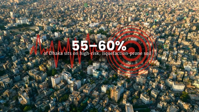
More than half of Dhaka could face severe damage during a major earthquake due to unplanned urbanization, wetland encroachment, and widespread construction on unstable reclaimed land, according to experts.
A joint study by the Rajdhani Unnayan Kartripakkha (RAJUK) and the Bangladesh University of Engineering and Technology (BUET) found that approximately 55 to 60 percent of the capital falls within high-risk earthquake liquefaction zones. Experts warn that if buildings in these areas are not constructed in accordance with engineering standards, a powerful earthquake could cause widespread structural failures.
The study, conducted across RAJUK's 1,528-square-kilometre jurisdiction, shows that more than half of Dhaka lies within the red and magenta liquefaction hazard zones, representing the highest levels of risk.
Professor Mehedi Ahmed Ansary of BUET's Department of Civil Engineering said these areas are vulnerable not only to liquefaction but also to ground motion amplification, where earthquake shaking becomes significantly stronger due to loose, sandy, or artificially reclaimed soil.
"These areas face higher seismic amplification because both hazards are closely associated with loose or reclaimed ground," Ansary said.
According to BUET's classification, the city has been divided into four Liquefaction Potential Index (LPI) categories. Areas with an LPI above 15 are classified as red, 10–15 as magenta, 5–10 as blue, and below 5 as green.
Ansary said a magnitude 7.5 earthquake could trigger severe ground failure and instability in red-zone areas, particularly near ponds, canals, and rivers where groundwater levels are relatively high.
He cited the 1985 Mexico City earthquake, noting that despite the epicenter being nearly 300 kilometers away, soft soil significantly amplified seismic waves, causing extensive destruction.
According to Ansary, sandy reclaimed land is susceptible to both liquefaction and amplified ground shaking, while soft clay-filled areas mainly experience stronger seismic vibrations. Both conditions pose serious risks.
He added that many new residential developments along the Balu and Shitalakshya rivers have been built on reclaimed land. Although safe construction is technically possible, proper soil improvement is essential before development. However, the high cost of ground treatment often discourages developers from carrying out the necessary work.
Ansary estimated that nearly 90 percent of Dhaka's reclaimed areas have buildings supported only by piles without improving the surrounding soil, creating significant vulnerabilities.
Referring to the 2001 Kandla earthquake in India, he noted that a building constructed on 60-foot-deep piles tilted by about 15 degrees because it was founded on weak, water-saturated soil.
He suggested that cement injection technology, similar to methods used at the Rooppur Nuclear Power Plant, could effectively strengthen sandy soils. According to him, reinforcing only the upper five to six meters of soil—even where reclaimed layers extend 40 to 45 meters deep—could substantially reduce earthquake damage.
Without improving the surrounding soil, both upper and lower weak layers remain unstable, increasing the risk of pile deformation and building collapse during strong earthquakes, he warned.
Similar concerns were expressed by Professor Md. Zillur Rahman, former chairman of the Department of Disaster Science and Climate Resilience at the University of Dhaka.
He said only about 35 percent of Dhaka is built on stable Pleistocene red clay, while the remaining areas have been developed on wetlands, floodplains, abandoned river channels, and low-lying basins, making them considerably more vulnerable to earthquakes.
According to Rahman, Old Dhaka, Gulshan, Banani, Dhanmondi, Dhaka University, Khilgaon, Motijheel, Farmgate, and Mirpur are comparatively safer because they are located on stronger soil.
Areas such as Basabo, Badda, Uttarkhan, and Dakshinkhan contain moderately stable soil, where firm red clay can be found 10 to 20 feet below the surface.
In contrast, land along the Buriganga, Turag, Balu, and Shitalakshya rivers consists largely of soft clay and recently reclaimed soil, with stable red clay lying 80 to 150 feet below ground, making safe construction more challenging.
Rahman warned that seismic waves can become up to twice as intense in former wetland areas. He stressed that building height and structural design must be tailored to local soil conditions to avoid resonance during earthquakes.
"Buildings can be constructed almost anywhere, but their design must match the characteristics of the underlying soil. Strict compliance with the national building code can significantly reduce earthquake damage," he said.
Former Bangladesh Urban Resilience Program Project Director Abdul Latif Helaly said the soft-soil hazard map had been completed years ago, but RAJUK has yet to fully integrate it into the city's urban planning framework.
RAJUK Chief Town Planner Md. Ashraful Islam said the authority received the map after the Detailed Area Plan (DAP) 2022 was officially gazetted.
"The map is currently under consideration and will be incorporated when the DAP is updated," he said.
Meanwhile, Real Estate and Housing Association of Bangladesh (REHAB) Senior Vice President Liaquat Ali Bhuiyan said member developers are following the Bangladesh National Building Code (BNBC) to reduce earthquake risks.
"The steel, cement, and other construction materials we use are manufactured with earthquake resistance in mind," he said.
Bhuiyan also noted that REHAB opened a control room following the recent 5.7-magnitude earthquake, but no member projects reported significant structural damage.
However, he cautioned that the impact of a major earthquake measuring 7.0 magnitude or higher remains difficult to predict with certainty.


Comments Here: